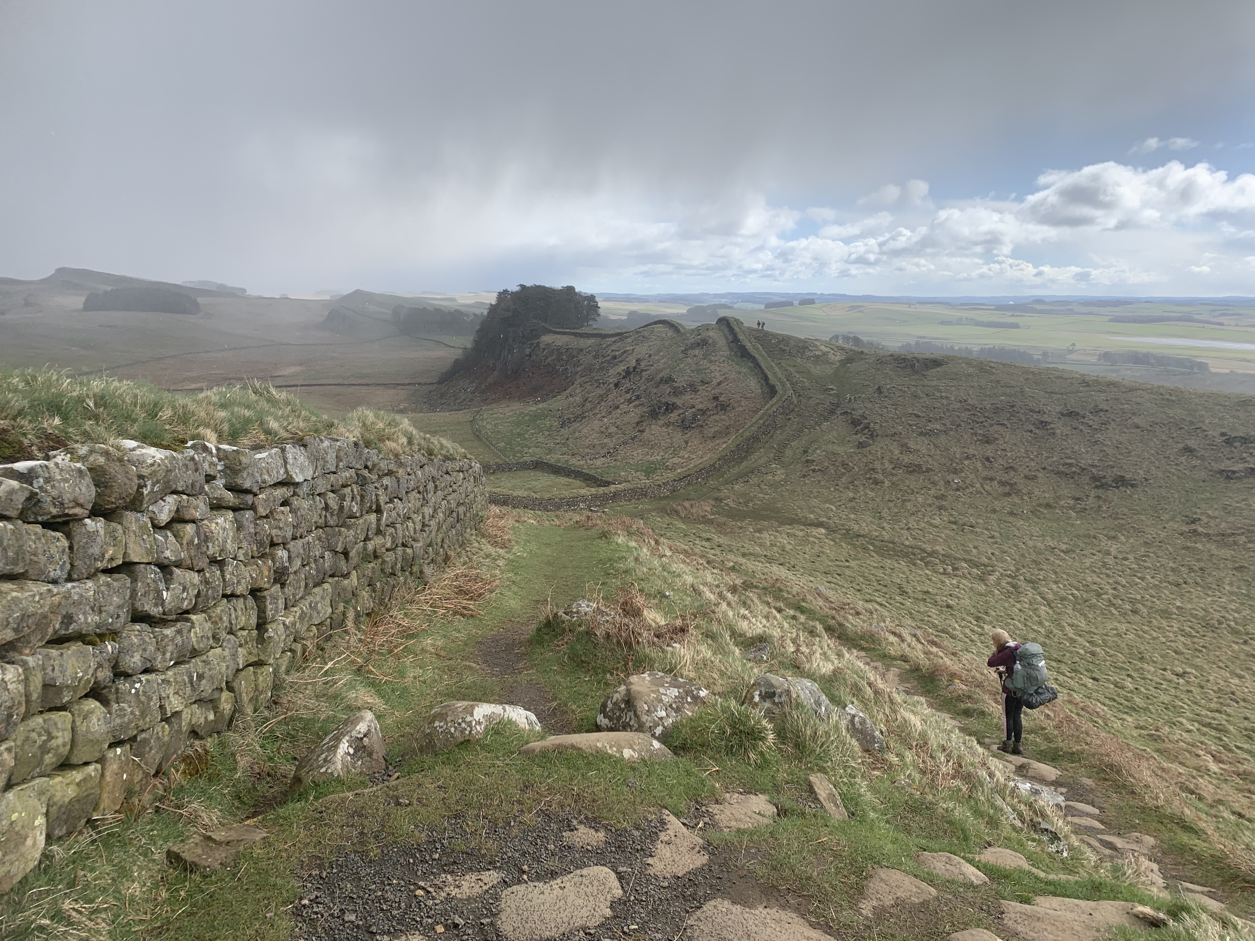
Hadrian’s Wall Path is a 135km (84 miles) National Trail from Bowness-on-Solway, Cumbria to Wallsend, Newcastle-upon-Tyne. As you can guess from it’s name, the trail follows Hadrian’s Wall, a UNESCO World Heritage site that dates back to the 2nd century AD. The wall was built by the roman Emperor Hadrian and marked the boundary of the Roman territory as they never managed break the border into Scotland. Much of the wall was dismantled and used for building materials in the area but, plenty remains to get an insight into this incredible frontier. This is a trail for those who enjoy history and walking.
Now, I’m not particularly that person. We stopped off on Hadrian’s Wall on a recent trip to Northumberland and it is definitely worth a visit, even just for a few hours, if you’re passing through. However, we did only spend a small amount of time there and decided that we wanted to experience a little more of it. On the Easter bank holiday, we decided we would utilise the time off work to do just that.

A Change of Plan
Initially, our plan was to walk from Brampton to Chesters Fort. It is suprisingly difficult to pick out a three day segment which had public transport back to the start, or so it seemed at first. However, we soon devised a plan. We’d park the car near Brampton and then get the bus from Chesters Fort to Haltwhistle or similar and get the train back to Brampton. That was the plan and I mention it in case you are also looking for a three night camping trip along the wall. Unfortunately, our plans swiftly changed.
The weather was not looking great. There were high winds forecast and it was going to get down to the minus temperatures. Our sleeping bags just weren’t going to be up for the job. So, a few days beforehand, I ordered us some new ones from Alpkit. Through no fault of Alpkit, we really struggled with the delivery. Living in a flat means it’s not easy to get parcels and so, we decided to wait in on the Friday to see if the sleeping bags would arrive. Sadly, they did not and it was much later in the day on the Friday than we had planned that we actually left for the trip.
Trying to walk the distance we had planned from Brampton to Gilsland would have been pointless.We would have arrived late and it just wasn’t realistic. Instead, we drove to Gilsland, found free parking and walked the 1 or so km to Chapel House Farm Walkers Campsite. Our trip was now Gilsland to Chester’s Fort.
Day 0: Gilsland
As I said, our night in Gilsland was spent at the Chapel House Farm Walkers campsite which, as the name suggests, is only for walkers. We felt somewhat like we’d cheated given that we had barely walked at all at that point and, that evening only intended to walk to the pub and back! It was a really lovely campsite. It wasn’t busy at all – surprising given the bank holiday; I highly recommend stopping here if you’re on either the Pennine Way or Hadrian’s Wall Path. It is on a working farm and the owners were really lovely. There aren’t any showers here but there is a toilet and plenty of space to pitch up. We walked back to nearby Gilsland for dinner at The Samson Inn which is a community run pub which over 50 locals have invested in to keep it open. The food on offer was classic pub style meals and it was a great way to start the trip. We then nipped down the road to The Bridge Inn for a drink before walking back along the path to the campsite. What more could you ask for!
Day 1: Gilsland -> Haughtongreen Bothy
The next morning, we woke up having not had the best night sleep. It was a cold one. We were very glad that the next night we would be in a bothy as Storm Dave was on the horizon and it was bound to get colder. Safe to say, I was very much lamenting the fact that our new sleeping bags hadn’t arrived whilst trying to burrow deeper and deeper into my sleeping bag overnight.
After a quick breakfast of porridge, we packed away the tent and as Chapel House Farm site is on the wall path we were on track immediately. Initially, the path winds its way through farmers fields, crosses a road and a railway line before reaching the first historic feature of our walk: Thirwall Castle. This does not date back to the Roman times but was built in the 12th century and owned by the Thirwall family. It’s most famous resident Robert Thirwall was the standard-bearer for King Richard III in the final charge at the Battle of Bosworth in 1485. It is said that he continued to hold the standard despite his legs being cut off beneath him by William Stanley’s force. Like many of the castles and buildings in the area, Thirwall Castle was reinforced with stones taken from Hadrian’s Wall. Having fallen into disrepair in the 17th century, nowadays, it’s maintained by the Northumberland National Park Authority and is open to the public.


From here, the path continues on to Walltown Quarry which has a shop, cafe and some toilets. We had a quick stop of here to use the facilities and it did seem like a very popular spot with dog walkers and day walkers. You can see why as it’s the start of the better preserved section of Hadrian’s Wall. The path climbs slightly before running alongside the wall. Roughly 5km later, we arrived at Cawfield’s Lake. We had actually visited this spot on our way to Northumberland in 2025 as it features one of the highest standing sections of the wall. This time, we had a quick snack break on the picnic benches before continuing on. We were aware that the storm was due to roll in at around 4pm and our estimation was that we would arrive at the bothy at 5pm. It was already past noon so we needed to get going.
It is worth noting that, for most of the Wall Path, there are two path options. One follows at a higher elevation alongside the wall and the other is much flatter and cuts across the bottom. Nine times out of ten, we picked the higher path that went along the wall. It just made sense to follow it as closely as possible.


Not long after the 12km mark, we reached Steel Rigg car park which was where we opted to leave the Hadrian’s Wall Path. Off we headed into what would have been barbarian Scottish lands, according to the Romans in the 2nd century. You could, if you so wish, continue to follow the wall and then cut left straight to the bothy but, we wanted to take a more diagonal route so that we wouldn’t be walking the same bit twice. Unfortunately, this does mean missing out Sycamore Gap so, it depends on how much you value that bit of history. Alex had already seen Sycamore Gap and we decided that I could just see it another time. The diagonal was the best option for us.
At Steel Rigg car park, instead of following the path, we turned left down the road. Then, turned right down another lane towards Gibbs Hill Farm. Crossing the cattle grid, we made our way along the lane. As we walked along, I noticed some huge cows on a hill ahead and made a comment to Alex about how large they were. Naturally, the footpath went right through the field of Highland cows. I can’t say I was best pleased about that. I love Highland cows to look at, not to walk past. They also had calves which is always slightly more dangerous. It was completely fine though, we kept as far away from them as possible and walked swiftly along the footpath. We were walking towards a Wetlands Nature Reserve and you could tell with how boggy the path was becoming. Compared to the tarmac and grassy paths of the day so far, it made for a bit of variation.
After leaving the field of cows, it was around 3pm and we decided to stop for lunch. It was quite late in the day, but unlike with the Cumbria Way, I’d ensured that I was snacking throughout the day as needed so, whilst I was hungry, I still felt like I had enough energy to push on to this point. Tuna bagel sandwiches later and a plaster for Alex who had managed to slice his finger open on the tuna tin, we continued on. We knew we were on the final stretch of the day.

The nature reserve was actually really cool. The path skirts Greenlee Lough and, because of all the bog, a boardwalk has been constructed that essentially covers the entire left side of the lake. It was slippy in places but we were really pleased to have picked this route as it was again another bit of variation and a very unexpected one at that. The reserve is managed by Northumberland Wildlife Trust and the National Park. Sadly, we didn’t see all that much wildlife but, the wind was also picking up at this point and the lake was rather choppy. I’m not sure why they call this a lough which is the Irish version of ‘loch’ or lake. I’m glad we added this in.
Soon, we joined a gravel track which passes beside two houses. Oddly enough, the path goes right through the second houses’ garden. And I mean, right by the front door and along the driveway which is a little odd. There was an option to go around which we didn’t do but, I would advise doing that instead. The track ultimately joins the Pennine Way where it meets the southern fringes of Kielder Forest. We followed a grassy path for around 1km and the arrived at Haughtongreen Bothy at around half past 4 after a 20km day. Right on time!

This is a nice looking bothy with one storage room and a central room for sleeping with a fire. There is also a toilet. Some bothies have toilets but I can hand on heart say I don’t usually use them. Usually, they’re absolutely disgusting. This was not! It was a little outhouse less than 100 metres from the main bothy and was a bit like a portaloo shack. Don’t get me wrong – it’s still a hole in the ground at the end of the day. But, it had a proper seat and didn’t smell horrendous. Who would have thought that I’d be waxing lyrical about a bothy toilet…
The bothy was not empty. Three people were already camping inside. They had also spent the previous night and seemed intent on spending the full bank holiday here. We hadn’t factored in how close this bothy was to the main road that runs alongside Hadrian’s Wall. It’s probably only half an hour or so walk which means that the bothy is much more accessible to non-hikers. Whilst I think everyone should have a right to enjoy the outdoors, it was a little disappointing that we were spending the evening with people who wanted to use the bothy as more of a hangout. From the sheer number of bothy books (a guest book of sorts where people write about their experience), it seems like Haughtongreen bothy in particular is used a lot in this manner. Another group of Australians arrived later too with the same intention. Overall though, none of them were particularly disruptive so, it was a positive experience still. And, they had kindling for the fire which was incredibly helpful in the cold. With the wind gusts hitting the side of the bothy, I was extremely glad not to be in a tent.
Rations packs and a few games of cards later, we retreated to our sleeping bags wearing our thermals to keep warm.
Day 2: Haughtongreen Bothy -> Greencarts Campsite
After a breakfast of porridge, we repacked our bags and set back off. Initially, it was a case of retracing our steps back to the gravel track and tracking the Pennine Way back to the wall. This was a lovely section as approaching the wall from this perspective gives you a real sense of why the Romans chose this vantage point for it. It was a bit boggy in places and, unlike on other parts of this walk, it felt very remote. You did get the sense that the wall marked the end of civilisation, even if that’s not strictly true!
The Pennine Way departs the Wall alongside Housesteads and so this was where we rejoined it. This is an incredibly popular spot and it was bustling with people at half past 10 that morning. It’s actually Britain’s most complete Roman fort, flanked by the wall. Keep an eye on the way marking here as we actually went wrong twice. Instead of running in-front of Houseteads, the path runs behind it and then bears left into the woodland after King’s Hill. Approximately 3km a later, the path dips alongside the main road that runs along the wall and that is basically where it stays.
This section got surprisingly busy. I’d probably say it was the most people saw out on the trail, either doing day walks or the whole thing. We also passed lots of people running the trail too which is pretty cool. I can see why as it isn’t that technically difficult and you still get the enjoyment of visiting the historical aspects but at a much faster rate.


Hadrian’s Wall Path somewhat pointlessly crosses the road for less than a kilometre to visit Brocolitia and the Temple of Mithras. To say it’s pointless is a little harsh – I was getting a bit hangry at this point – as this is another of the large forts along the wall and also where the Romans dedicated a temple to the god that they worshipped. We had been here before too and my hanger was worsened by the fact that every 15 minutes or so, we were being pelted with hail at this point. It didn’t lend itself to a nice lunch stop. It was like the weather was teasing us – bright sunshine one moment and hail the next! I will say, it was better than it just raining though as we actually weren’t getting that wet.
We crossed back over the road and followed the path through a couple of fields before we reached Limestone Corner. This had a rocky dip in which we could shelter from the wind somewhat and have a quick lunch stop. We also consulted the map here to see how long we had to go before reaching our campsite. At this point, the wind and hail were making a night in the tent not look like a great prospect. We knew this was forecast to be the coldest night of the trip so far and we’d have the task of packing and drying the tent the next morning. I had noted when I booked this campsite that they also had a bunkhouse so we were crossing our fingers that they had some space left there…
You don’t actually need to consult your map too much all Hadrian’s Wall Path as it is fairly self-explanatory for navigation and is well way marked where it isn’t. We were surprised to find that we had less than 3km to go until we reached the campsite and we’d likely be there within the hour! It was only about 2 o’clock so we’d made great progress, albeit with a shorter 16km to cover on this second day. It was certainly a jolly short walk to the campsite after fuelling up.
Unfortunately, our hopes of getting into the Bunkhouse were dashed; it was fully booked. However, the woman who owned the campsite kindly let us stay in a semi-converted barn. It had no heating but it was for all intents and purposes a converted barn. There were bunkbeds, a kettle, a fridge, books and games – we certainly weren’t going to turn it down. Apparently, they usually open this in the summer only but we were very grateful for it. With plenty of time before dinner, we had a nice shower, watched some Netflix on our phones before tucking into our ration packs. It felt like a weirdly chill evening for being on a long-distance trail but, we weren’t complaining.
Day 3 – Greencarts Campsite -> Chester’s Fort (and Gilsland)
That evening was the best night sleep I’d had of the trip so far! We didn’t have far to go on Day 3 at all so we took our time getting sorted and packed away before heading off for a short walk to the bus stop outside Chester’s Fort.
We exited the farm the opposite way to how we arrived, heading down the lane before turning right onto the main road. There isn’t a pavement but there is a decent grass verge on both sides of the road. It also wasn’t very busy which helps and you’re only on there for around 1km. At the junction, you rejoin Hadrian’s Wall Path and, for a short while, it’s back to walking through farmland.
After just over 1km, the path joins to a lane and you turn right into Walwick. From here, it gets a little less excited as you’re walking on the pavement all the way to Chester’s Fort. This is overall just a 4km walk to the bus stop so you’ll be there in about an hour. It doesn’t take all that much effort as it’s mainly downhill, too!
You could extend the walk to Chollerford which has bus connections to Hexham but, unless you want to do the whole route, pushing on to Heddon on the Wall doesn’t seem like any additional variation. The path continues to follow the Military Road until Heddon on the Wall before dipping into Newcastles’ suburbs. To be honest, we had a fabulous few days out on the Hadrian’s Wall Path and were well satisfied by what we had seen. I think this is the perfect section. Arguably, it would have been that little bit better with the addition of the first day from Brampton but, circumstances as they were, I’m really happy with this. I worried that the completion-ist in me would regret not doing the whole thing but, I don’t feel as if we missed out. It was the perfect bank holiday.
From Chester’s Fort, we got the bus back to Greenhead. We arrived at the bus stop 2 minutes after the bus was scheduled and luckily, it was a little late so we managed to hop on minutes after arriving. Had we missed this half past 10 bus, we would’ve headed into the Chester’s Fort museum. That had been our initial plan but, given that the bus arrived as we were checking the times, it seemed silly not to just get on! Go North East run the AD122 bus service roughly every two hours and it follows that main road that we’d been walking parallel to this entire time. It passes lots of Hadrian’s Wall sights including Housesteads, Vindolanda, The Sill and visits the towns of Haltwhilstle and Hexham. We got off at Greenhead as this is the closest it gets to Gilsland and our car parking spot. It is only about another 3km so our daily total was 7km! We were back at the car by noon and were able to stop for a lovely lunch at Alston on the way home. It was well planned.
That brings me to the end of our 3-ish days walking along Hadrian’s Wall Path’s central section. If you want a flavour of the highlights of this long-distance trail but don’t want to walk the whole thing, this would be an ideal walk to copy. You can see the full route for yourself on MapPedometer. In the end, according to my Garmin, we’d walked 43.83km.
Have you walked Hadrian’s Wall Path?
Amie x


Leave a Reply