The fact that I’ve only posted one walk on Dartmoor – a circular route around Okehampton – is absolutely astonishing. This national park played a huge role in the first years of my hiking journey and is probably responsible for me falling in love with it in the first place. Or, Devon more generally anyway. The route I am sharing with you today was the first walk that I ever did on Dartmoor and, whilst it had some challenging moments, my overall feeling looking back is how much I enjoyed being out in the middle of nowhere. This is a great route and accessible by bus from Exeter, what more could you ask for?
As I said, you can get to Postbridge from Exeter using public transport. Before the train line opened back up from Exeter to Okehampton, this was one of the main routes to get out into Dartmoor. First Bus run the Dartmoor Explorer which travels from Exeter to Tavistock however, because it is specifically a ‘tourist’ bus, it is a little more expensive. In this case, it is best not to get a return ticket as the Chagford bus is not the Dartmoor Explorer, so separate tickets are required. It is a nice drive though as it takes you right through the heart of the Dartmoor villages before breaking out onto bleak moorland.
Difficulty: Easy
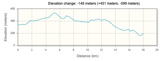
Distance: 18km
Elevation: 538m (-148 change)
OS Map:
Notable Features: Fernworthy Stone Circle, Hartland Tor, Sittaford Tor, Kestor Rocks
Look Out For: Dartmoor ponies

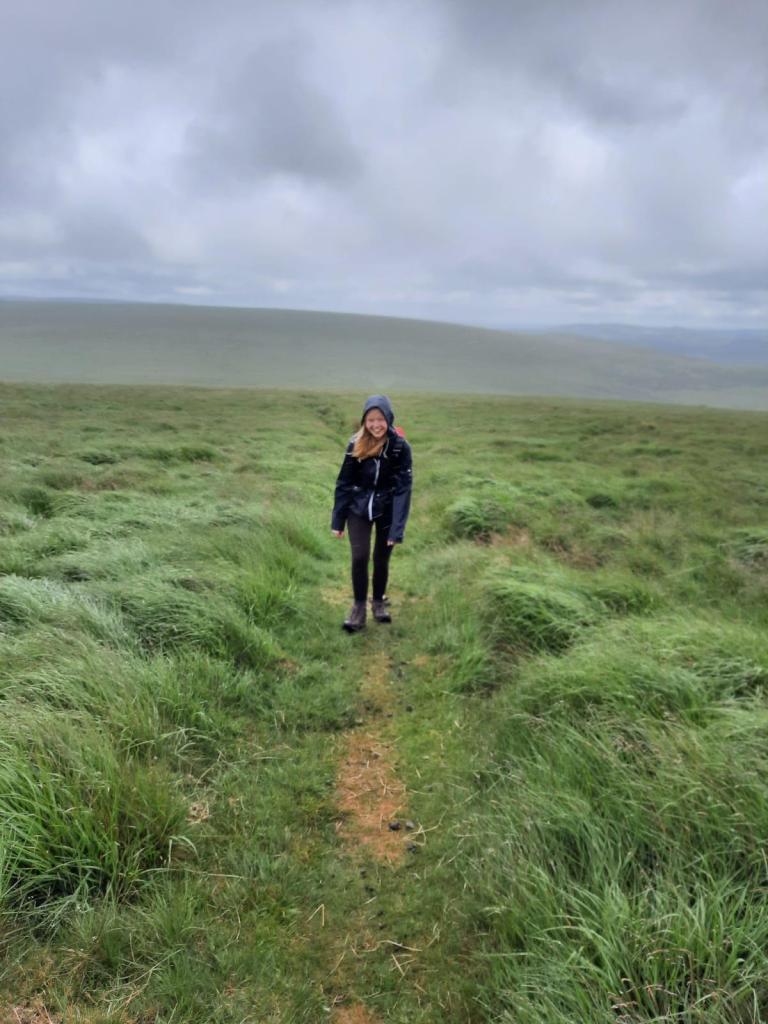
The Lake District has wainwrights, Scotland has munro and Dartmoor has tors. A tor is the term used to describe a free-standing rock outcrop and Dartmoor is covered with them. Each has been given a name and there are specific challenges for walkers in the national park such as Ten Tors where you must reach ten tors within 24hrs. This is a challenge usually completed by teenagers growing up in the area but it certainly doesn’t exclude adults who want to take on the task. What is actually classed as a tor on Dartmoor is up for debate however, I would say that this walk includes three of them: Hartland Tor, Sittaford Tor and Kestor Rocks (contentious, that one).
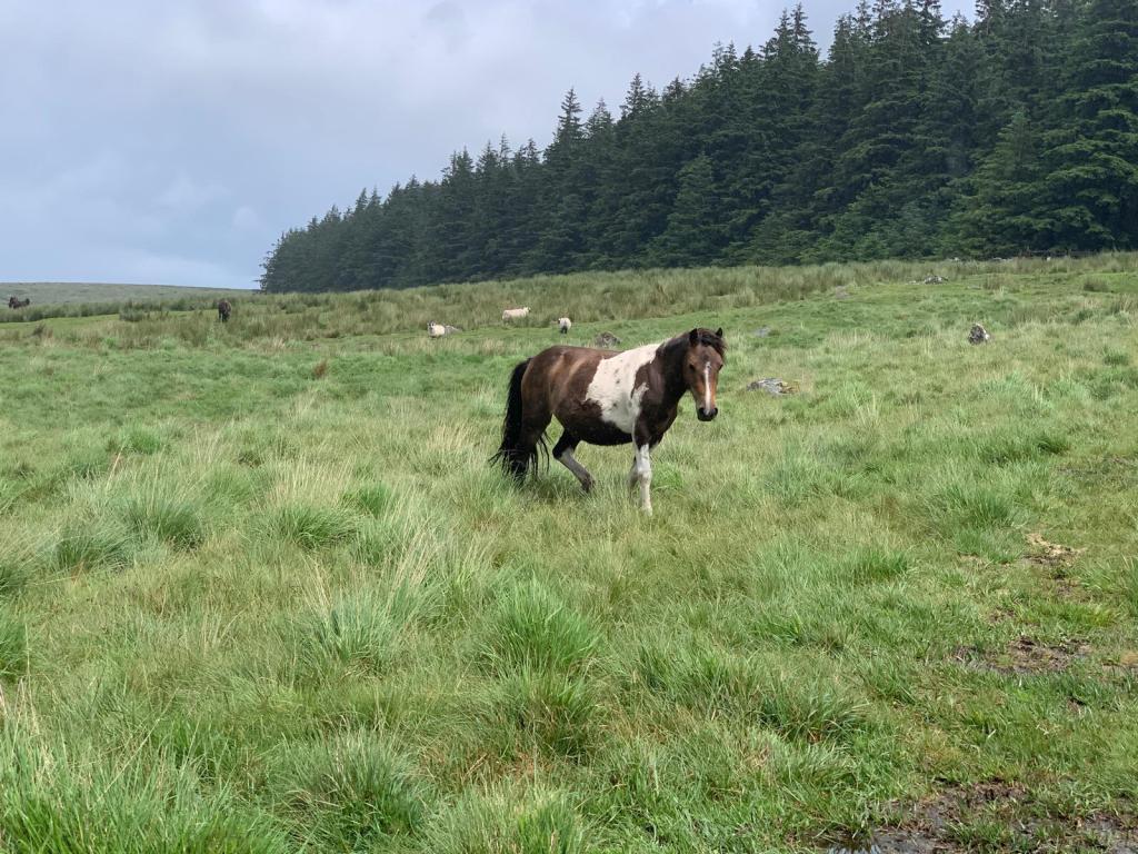
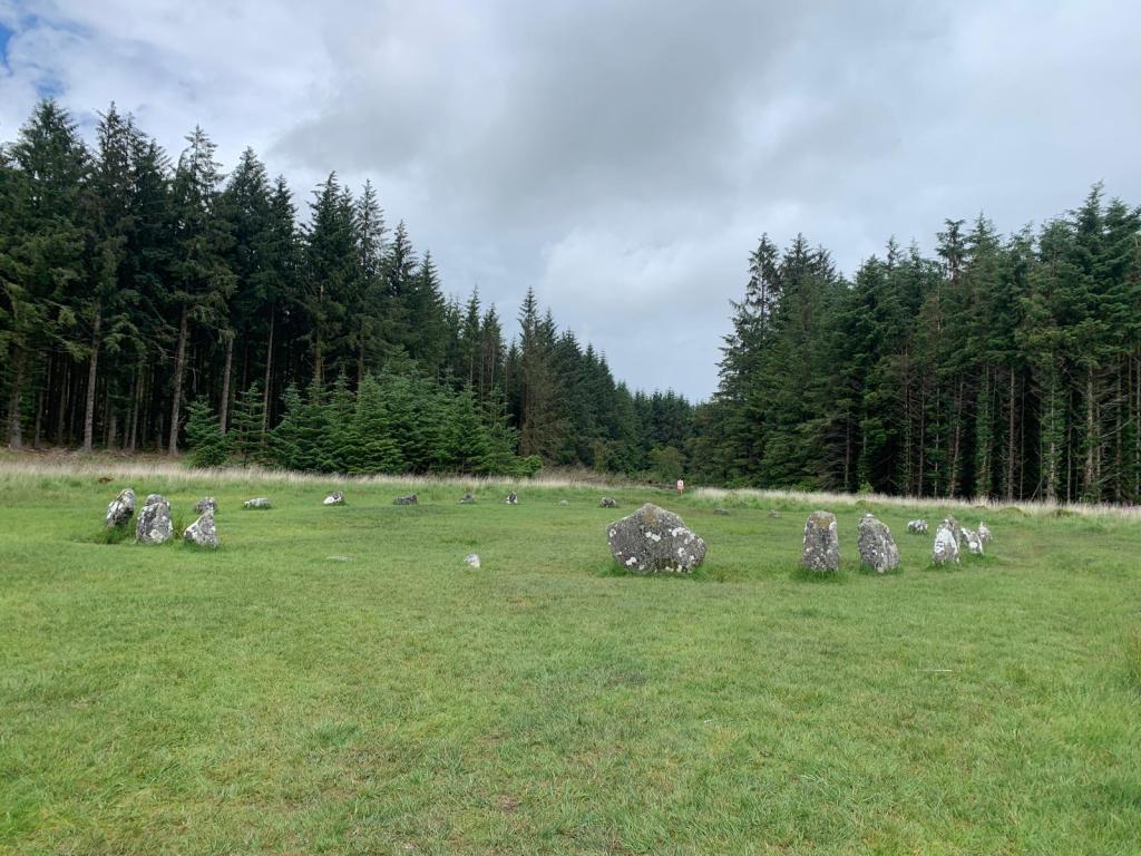
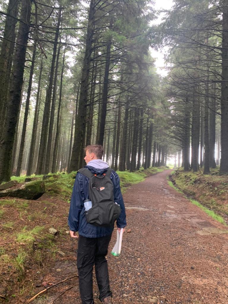
As well as tors, Dartmoor is also famous for its ponies which we saw on this walk and the different signs of old settlements. On this route, you’ll pass Fenworthy Stone Circle in the middle of a woodland. This was where we opted to have lunch during the walk as it is just under half way through the route. The forest also provided a little bit of shelter as the weather, as Dartmoor is known for, was rather bleak. You can tell how early on in my walking journey this walk was as my waterproof is what I would call a ‘shopping waterproof coat’ rather than one that is truly practical. Believe it or not, these photos were taken in July. As I always say, you don’t need to have all the gear when you’re starting out.
This forest actually caused us a lot of problems on the walk. As we attempted to follow the paths through the forest, we quickly realised that these had changed since our OS map was printed. With forest areas, deforestation causes so many changes as they create new paths for their machinery and also cut others off. We wandered down to Fenworthy Reservoir and got stuck in bog then cut off by fencing. The paths that we attempted to take were no longer footpaths at all. At one point, we ended up trying to walk through all the broken and dead bracken from the trees which didn’t make for comfortable walking. Admittedly, this was a far from enjoyable part of the walk and I really struggled with it. I’ve attempted to plot a slightly different route to share with you today that hopefully still exists and is a bit easier going however, I can’t guarantee that that hasn’t changed and disappeared too. You’ll have to make your own way if that’s the case but a compass and map will serve you fine.


Unlike walking in other national parks, Dartmoor is also relatively flat in comparison. This walk also starts at just under 400m and the highest point reached is 538m so you don’t gain all that much height. In fact, the overall elevation change is minus as Chagford is much closer to sea level than Postbridge at around 200m. The magnificence of Dartmoor is not the height but the history.
The bus back involves taking the 173 from Chagford to Exeter. As of April 2024, the last bus is at 18:25 and therefore, you must make it to Chagford for that time. It is only a small village and the bus leaves from the central square. We managed to have a quick drink in the local pub before hopping onto the bus. From what I remember, there is one pub that seemed incredibly fancy to us in the moment when we were drenched and coated in mud. We didn’t want to go in there in our muddy state so opted for the smaller local pub. It was a drink of tea rather than a pint though….
Traipsing over the wood and bracken aside, I really enjoyed this walk and writing this post reminds me how great public transport can be. You have so many more options when you don’t have to return to the place you parked the car and it’s a shame our national parks aren’t better connected, the Lakes especially.
As always, you can take a look and modify the route for yourself here. Check out the step by step of the route below:
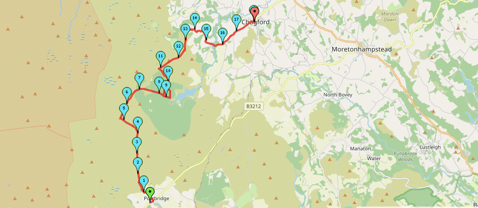
Start Point: Postbridge Car Park
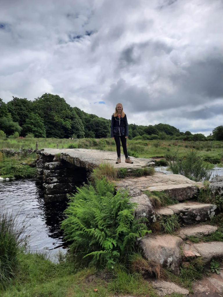
- Head down the road towards the river and head down the footpath on the left. This is directly across from the Postbridge bridges.
- Follow the footpath around the edge of the field, keeping to the boundary wall.
- The path soon meets the river. Follow it alongside the river and over the stile.
- Continue straight to Hartland Tor, keeping on the path to the right past the tor.
- Follow this path around the left, then continue straight at the crossroads. Sittaford Tor should be ahead.
- Continue to Sittaford Tor and head over the stile.
- The forest should be on your right. Follow this path as it enters the forest.
- At the entrance to the forest, the path meets a track. Follow this track through the forest.
- Head straight down the track, ignoring any other paths leaving it. After just over a km, there should be an opening with a stone circle on the left.
- After looking at the stone circle, head back to the track before taking the next path on the left.
- Continue to follow this path out of the forest.
- Once you have reached the open moors, turn left, skirting the edge of the first.
- At the edge of the forest, take the path on the right passing Shovel Down.
- Head over the crossroads and then take the fork on the left towards Kestor Rocks.
- At Kestor Rocks, take the path on the left of the rocks, towards the road. Turn right at the road towards Teigncombe village.
- Follow the road through Teigncombe. Once you have exited the village, take the next road on the right towards Thorne.
- Complete a small dog leg, right and then left to continue straight to Chagford.
End Point: Chagford
There is a little bit of road walking towards the end of this route but that does not take away from its bleak Dartmoor atmosphere overall. I miss this national park!
Have you walked in this area?
Amie x


Leave a comment